Hamburg, Germany is Europe’s third largest port city, known as a creative eclectic city and hub of science, research, and education with a demonstrated commitment to innovation and community engagement. This is a primary reason Hamburg was chosen as one of three cities for the inaugural launch of The Human Action Lab, a series of virtual salons designed to bring leaders together across four sectors – government, industry, academia, NGO/civil society – to showcase digitization and data-enabled efforts to mitigate urban challenges.
The Hamburg event, which took place on November 29, revealed several cutting-edge solutions that are the result of a unique cross-sector partnership between the Free and Hanseatic City of Hamburg and the City Science Lab at HafenCity University (HCU), a research institution in Hamburg also known as the University Of The Built Environment and Metropolitan Development that is engaging in a unique partnership with the MIT Media Lab City Science Group.
The focus of these collaborations is to encourage community input through digitization, data analysis and data visualization. The work is exciting, built on open source principles and developed to inspire other communities to engage in new dialogues and creative solutions.
The History of Digitalization in Hamburg
Digitalization has been placed high on the political agenda in Hamburg since 2011 when Olaf Scholz (the incoming German chancellor) took office as First Mayor. One later result of this policy approach was the founding of the Department of IT and Digitalization (ITD) in the Senate Chancellery. Dr. Adrian Fiedler, deputy head of the Digital Strategies Unit at ITD, described the city’s efforts to go beyond a tech-only perspective with a special emphasis on engaging the input of local residents.
Hamburg’s Digital Strategy lays emphasis on the goal that “technology is not a means in itself but should always be seen as a tool to make the life of citizens better”, which is the main idea behind playing an active role as administration in this field. To do this, cooperation is the key and Hamburg tries to cooperate in as many different settings as it can – with academia, with the private sector and with social organizations.”
Solution #1 – Digital Participation System (DIPAS)
Hamburg, like many urban centers, is experiencing a surge in population which brings forth several capacity challenges including housing accessibility and affordability. Mateusz Lendzinski, Ministry for Urban Development and Housing with the City of Hamburg explains, “Everybody needs a place to live, it also brings us to the problem of rising rents. Our answer to that is a very intensified housing program but urban development projects are not liked by everyone. So you have conflict.”
The City of Hamburg faces this issue full on and extends extra effort to host an inclusive community conversation that involves traditional as well as informal engagement methods. This work, named DIPAS, is a joint project by the Ministry of Urban Development and Housing, the Agency for Geoinformation and Surveying (LGV) and HafenCity University.
“The key is that we use mixed methodologies: we have on-site events, we have town hall meetings, we have YouTube streams, and we also use digital tools.” The online tool is a web interface where people can access interactive maps and use geospatial data such as zoning plans, land use plans or green plans. “All of the information that we have as planners is being made accessible to citizens through this web interface where they can also submit geo reference feedback in order to make the planning procedure a bit better,” says Lendzinski.
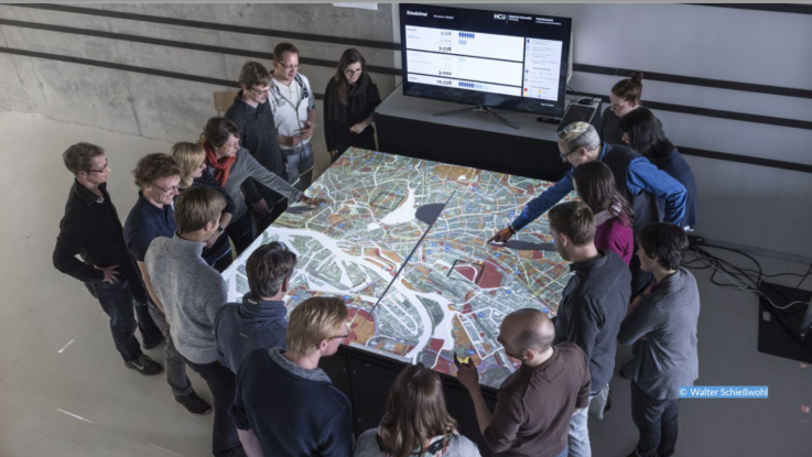
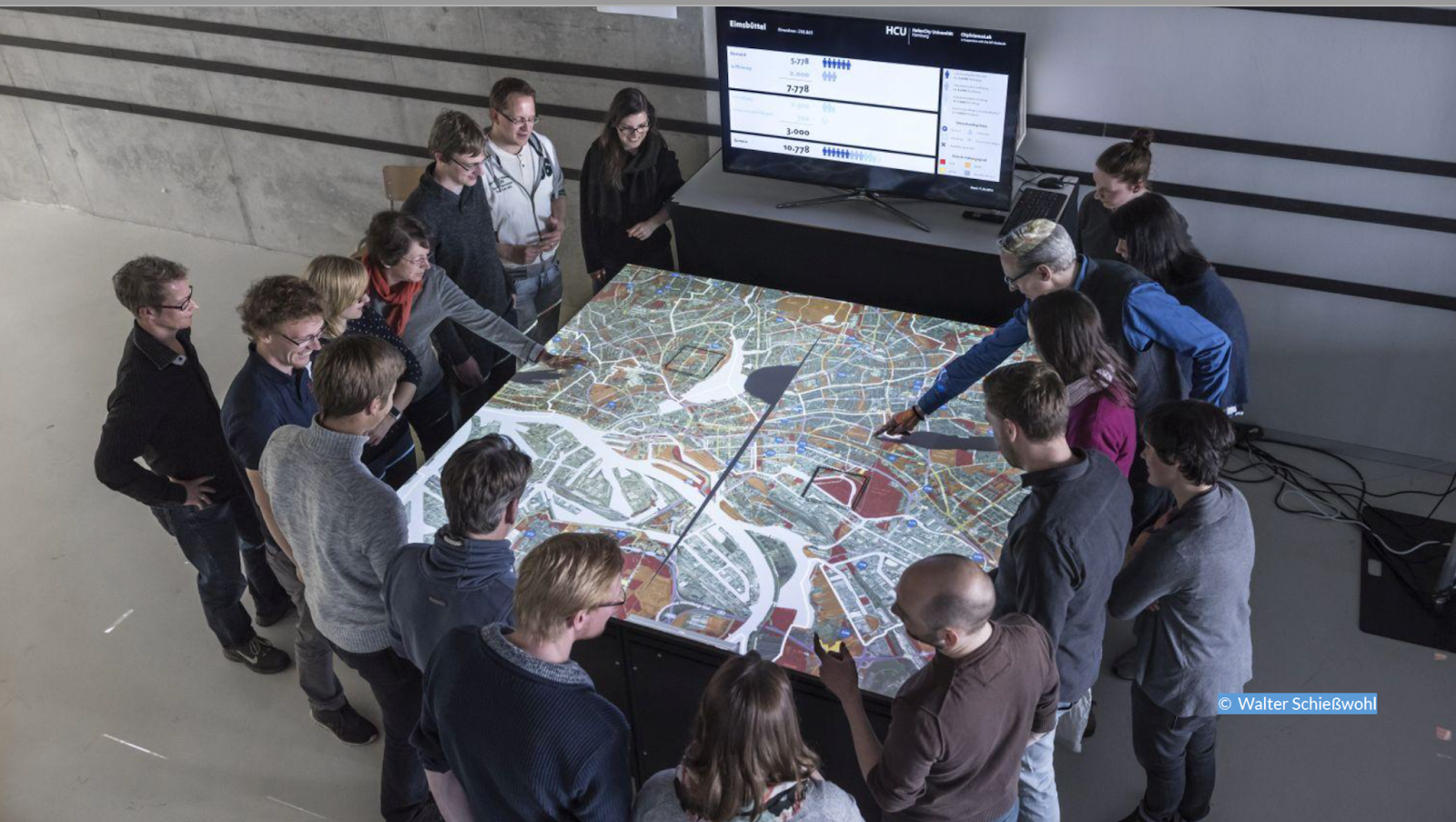
What makes this work truly unique is that the digital experience is combined with an in-person tool, the DIPAS Touchtable, which is an interactive device that demonstrates 3D city models of urban designs. Bringing data to life through the Table can bring new energy to heated discussions and encourage shared perspectives at town hall meetings and workshops. Being able to see the data, experiment with ideas and see the impact in real time is transformative. The resulting dialogue can be synchronized with geospatial data which all originates from one database. This makes it easier to process, integrate and combine with other data sets and even processed by other applications. This 360-degree participatory tool is the next generation of citizen engagement.
Solution #2 – Cockpit Social Infrastructure (COSI)
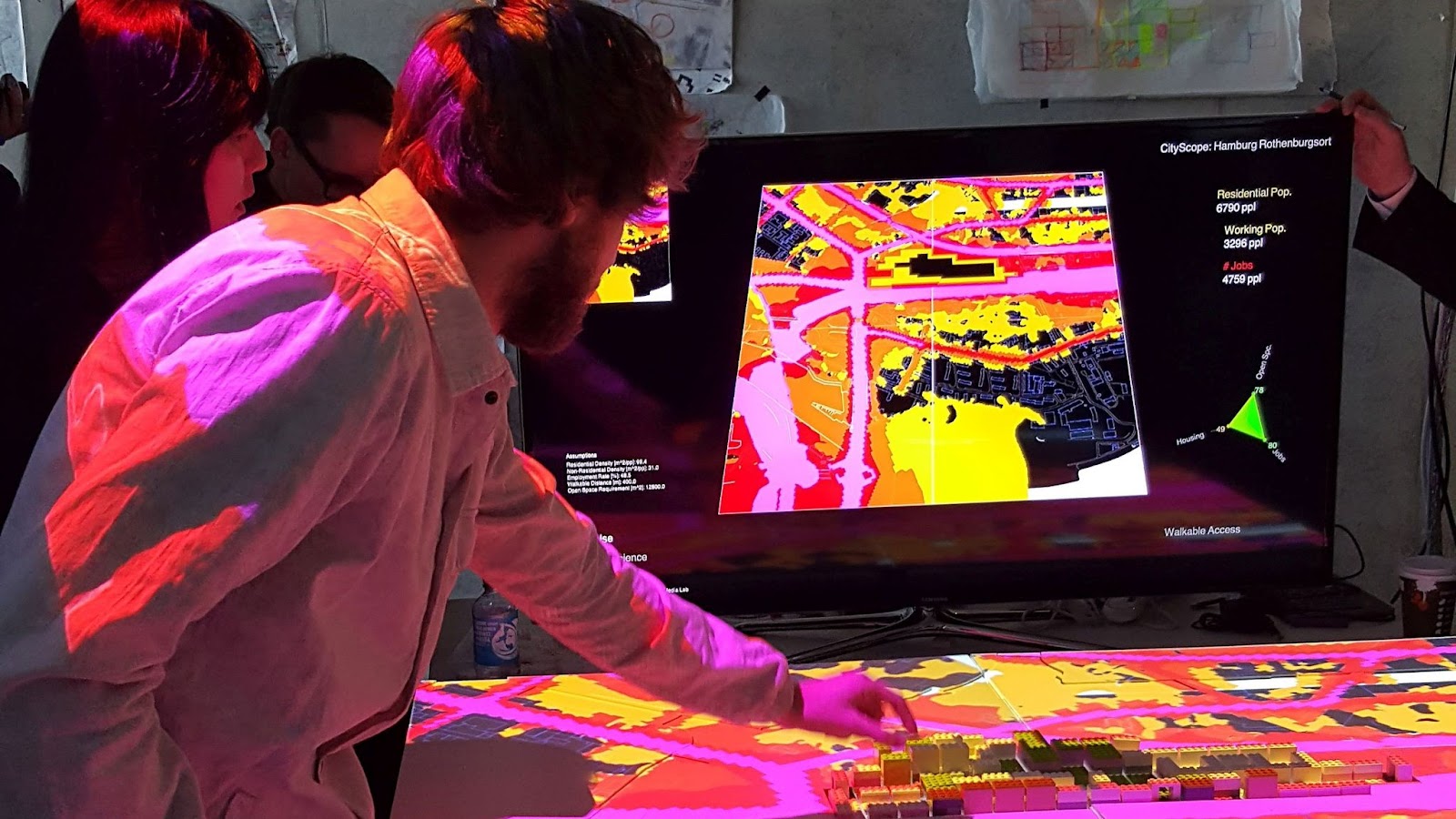
One of the key challenges with matching urban development and citizen engagement is that urban information is mostly abstract. Johanna Fischer and Daniel Schulz with the City Science Lab, led by Gesa Ziemer, are part of the COSI project, which, “allows users to iteratively try out different setups … build and compare different solutions, and record all data in all sorts of compatible formats.”
COSI is a professional data cockpit tailored for urban planners to provide visualization and analytical tools as well as simulation. All of the information, from regional statistical data down to the facility level, is provided in one glance. This empowers full-scale analysis so that users can test hypothetical scenarios and simulate results.
Using a scenario of school location, Fischer demonstrated how it works. “The COSI tool allows the planner to visualize where schools are located and also combine this view with regional data that shows the distance that students have to walk to school. Then you can explore how building new housing or a new school could impact the students.”
Schulz elaborates on COSI’s accessibility, “We enable users to iteratively try out different setups. Like for example, now with this new school that I created here and that allows you to build and compare different solutions and record all the data in all sorts of compatible formats like Excel tables, images for the graphs, geodata for further processing and other tools like Esri that the planners and decision makers then can use to justify their planning.”
COSI is a key technology to develop evidence-based solutions and a more transparent planning process. Urban planners are not empowered not just with data trapped in spreadsheets, but with a powerful tool to inspire creative solutions. The COSI tool hopes to build a circular monitoring system to support in-time demands and deliver quicker analysis and iterations.
Solution #3 – Connected Urban Twins (CUT)
CUT is a cooperation project of the cities of Hamburg, Munich and Leipzig to further advance urban data platforms and digital twins for cities.
When CUT started in 2021, Rico Herzog and Rosa Thoneick, members of the CUT research team at the CityScienceLab of the HCU, examined digital urban twin best practices from all around the globe and made the astute observation that something was missing: people.
“In the vast majority of renderings, there is not a single human,” observed Herzog. Given that CUT’s goals are not only technologically driven, but focus on benefits for people, this is an important distinction. “That says something about the nature of many of these urban twin projects of the basis where they come from, and maybe also at the motivation for which they are being done – from a very technological view.”
Designed as a project from cities for cities and their inhabitants, CUT focuses on the benefits of digital twins for integrated urban development and citizen participation. So Herzog and Thoneick embarked on an approach to put humans at the heart of digital urban twins. Their research questions include: How do we have to embed digital twins into urban development to foster a sustainable transformation? How do we have to design digital twins in order to support agents with the co-creation of a sustainable transformation? How can we integrate uncertainty and urban complexity into digital, urban twins?
The first results of the CUT research project are a mix of methodologies that include a storytelling digital tool contextualized by data, a data collection tool as well as a real world lab. People are invited to learn, to provide data and give feedback and then test use cases that can be implemented within the Digital Twin tool. This citizen co-creation provides feedback on usability and how to invent and improve new functions and technologies.
In December 2021, the research team of the CityScienceLab Hamburg have launched their first use case on mobility for unpaid care workers. With the CUT storytelling tool, people can better understand the issues facing unpaid care workers, who have different needs than employees on an everyday commute. What makes this so unique is the bi-directional engagement where unpaid care workers are invited to supplement the stories with their own experience. For example they can provide data on the transportation options they choose, the costs associated and the challenges they face. Urban planners can use this information to make more equitable decisions.
Thoneick explains, “We want to tell them what we know and what we don’t know about mobility patterns. For example, maybe care workers have to take a different route because the pavement is not suitable for strollers.” In the future, this early scenario planning can extend to other mobility issues, resulting in public facing tools that are self-explanatory, accessible and experimental. In addition, the CUT research team is also undertaking an exploratory modelling approach which expands from two or three deeply-focused scenarios, to 200,000 or 300,000 scenarios in order to see likely patterns.
Solution #4 – Participation, Collaboration & Multimedia (PaKOMM)
Continuing on the theme of engaging citizens and residents, the PaKOMM project explores multimedia as a way to further connect with people and get them involved in complex decision making and planning. Augmented and virtual reality technologies (AR / VR) are being tested as a solution for multi stakeholder planning workshops. Imanuel Schipper with HCU expands, “We aim to enable people to experience, discuss and alter their own co-creation results. We want to work with multi stakeholder and multi users to really try to design together.”
These modalities are explored in a three-step setting: (1) a workshop that is moderated on a touch table where people can visualize and discuss, come up with questions, discuss and add areas of exploration (2) VR setting where people can work collectively in a multiplayer mode on a design (3) AR to check out the design and alter them onsite, on the spot. When all of these modes are brought together, the level of co-creation potential is incredibly unique. VR makes it possible to have people working in the same physical space, but also working remotely with the opportunity to then come together and work collectively.
Schipper announced that one year into the three year research, the prototype is ready. The next steps will be workshops and qualitative interviews and in-setting research. “For all of those interested in a participatory urban planning process, that includes information and alternation, co-creativity and collaboration, different media and mixed realities, you will be interested in PCOM.”
Summary
As we approach a transformative era of city co-creation, Hamburg is setting a beautiful example for collaboration between sectors, not only between academia and city government, but also with private partners who can boost a certain technological development further and scale results. The next step is to continue the research and expand the effort to other cities. The projects are designed to be open, to be iterative, to be shared. It is an evolution and proof that co-creation can be existing, successful and obtainable.