The Canadian company, Miovision Technology has launched a new venture called Miovision Labs in order to take advantage of the massive data sets collected by the company’s intersection controls that are used in 13,000 cities around the world.
Miovision helps cities monitor and change intersection signals according to traffic volumes or changes caused by accidents and construction. Cameras watch the road and transmit real-time video to control centers, while sensors in the road count individual vehicles. The technology also monitors how long it takes for vehicles to travel between intersections. A city using such technology at 500 intersections generates about one gigabyte of data a month, or about six terabytes a year.
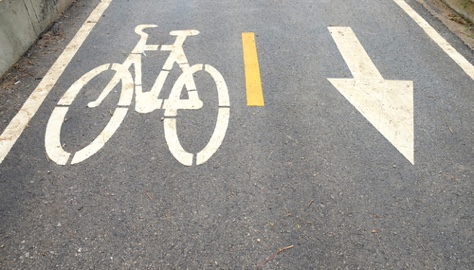
The lab is already working with the University of Toronto, a U.S. agency studying how trains and trucks deliver freight within cities, and with the World Bank on how data can be used to make safer roads. The University of Toronto, City of Toronto and the Miovision Lab are researching collisions from a “conflict zone” — a place where vehicles are most likely to hit cyclists. Vehicles making right turns are the biggest problem, according to the data.
“The idea is the research will lead them to mitigation strategies,” said Kurtis McBride, Miovision’s chief executive officer and co-founder. “Sensors embedded in roads could be used to warn drivers making right turns that cyclists are moving through their blind spot.”
Miovision Labs will partner with other researchers on smart city technology, but only if everyone involved agrees to share the results publicly. McBride calls this “open by default,” and wants the lab to be a rallying point for forward-thinking technologists.